Stream Restoration
|
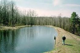
Elk Creek is a tributary that feeds into Loyalsock Creek, an exceptional value, high quality, cold water trout stream in the mountains of north central Pennsylvania. Over the past 40 years, the stream bank has been negatively impacted by more than six significant flood events. Much of the trout habitat is gone, stream bank erosion is severe, and the stream channel continues to shift.
Chief Oil & Gas partnered with the Sullivan County Conservation District and the Pennsylvania Fish and Boat Commission over the last three years to design and implement multiple phases of stream restoration along Elk Creek. Each phase focused on a specific section of the stream and involved upgrading the stream bank with a variety of log vanes and mud sills to protect the stream bank from erosion and to re-establish trout habitat that was degraded after the floods. This project was a team effort and involved a variety of stakeholders. The Fish & Boat Commission designed the project and obtained necessary permits from the state regulatory agencies. The Conservation District managed the project, procured the necessary supplies (including rebar, logs, stone and geotextile) and managed the heavy equipment operators. Chief Oil & Gas provided the funding, volunteers, safety equipment and catering for the projects. A big thank you is extended to Lewis Lumber Company, Brian Smith Excavating, and Insinger Excavating for providing supplies and experienced equipment operators. We would also like to thank the landowner for providing access to the stream to address sediment and bank erosion in the stream. We would also like to thank the Forksville Inn for catering the lunch for the week of the stream project. Thanks to this partnership, the stream banks remain stable and vegetation flourishes. Aquatic life is also showing improvement in and among the new habitat. |
This Elk Creek Stream Restoration video brought to you by Chief Oil & Gas
|
Mine Land Reclamation
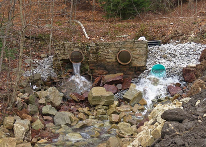
The Conservation District continues to actively support and sponsor mine land reclamation throughout the county. Past coal mining activities have left many scars are the land and have impacted water quality on the upper reaches of the Loyalsock Creek. Past mining activity has impacted water quality through the discharge of acid and metal polluted waters from deep within the mines. Surface mining has left numerous high walls of 40 – 50 feet and posed a serious concern to human safety. Through cooperation of landowners, state and federal agencies and the Conservation District, much of this land has been restored to cause minimal impact to the environment and eliminate human risk factors. The Conservation District has also worked hard to control the pollution impact of acid mine drainage. Through the cooperation of the State Bureau of Abandoned Mines, two large passive treatment systems are effectively alleviating acid concerns and allow metals to precipitate out of the water prior to entering the Loyalsock Creek.
Through the Rural Abandoned Mine Program (RAMP) and the Bond Forfeiture Program more than 163 acres of land has been reclaimed in the county. Although great accomplishments have been made, the district is still working to further treat acid mine drainage seeps and reclaim additional land.
The Conservation District continues to actively test and promote low cost effective treatment practices. Currently, two projects are being evaluated for effective acid treatment through the use of limestone sand and another project is testing the effects of inhibited sunlight on water treatment.
The Loyalsock Creek Watershed Association has joined in the fight to reclaim the Loyalsock Creek. In 2005, the Association joined with the Bureau of Abandoned Mines in an effort to design and install a passive treatment system in the Birch Creek Watershed, a tributary to Loyalsock Creek.
Treating Acid Mine Drainage Through
Low Cost/Low Input Treatment
Dealing with the scars of the past can be a difficult task, especially when those scars are from past coal mining operations. The area surrounding Lopez and Mildred in eastern Sullivan County, Pennsylvania is one of those such scars. Coal Mining in the area produced a unique coal that was neither hard nor soft. The term used to describe it is semi-bituminous and its use was found to be best suited for the manufacturing of automobile battery casings. After the boom era of minings was past, both towns became sleepy remnants of what used to be. One thing that has stayed with the area over all of this time is the effects of invasive nature of the old mining companies. Reclamation or protecting water quality was not even a consideration during the old coal boom days and therefore, nearly a century later we still have the misfortune of dealing with mine drainage problems, acidity problems in the local streams, culm piles riddling the landscape. All of which have stressed the region’s ability to naturally buffer acidic water and maintain a good level of water quality.
In the pursuit to alleviate all that mining has left behind, it was soon realized that in order to make any improvements, money was always the factor. And the case was always never enough money. The county has been fortunate to be selected by the DEP Bureau of Abandoned Mines for several large scale site reclamations and two significant passive treatment systems that treat deep mine discharge tunnels. Areas were still found to be impacted with higher than desired acid levels.
In an effort to wage our own war on these small areas, mainly mine seeps into water impoundments, we set out to test some KISS theories and see what difference we could make. By the way, KISS is Keep it Simple Stupid. Our first attempt at this method of treatment came in the mid 90’s when we set out by dosing some streams in the area with limestone sand. The problem with direct dosing is that it makes “slug” of treatment and does little for any type of longer term impact. We then decided to try keeping limestone sand piles up and away from the water and allow precipitation events carry the high CaCO3 to the water. This seems to do the trick. We have since placed several piles of the sand material on seep sights of old mine land and have found that it will affect pH and it will provide for a fairly decent lifespan. We have some piles that have been effectively adding to the buffering capability of a lake on White Ash land Association property for more than three years now. Prior to the placement of limestone sand, we performed a rather laborious task of applying lime directly to the lake to shock treat the less than desirable pH of around 4.9. Following the shock treatment and placement of limestone piles, pH has been maintained at readings from 5.3 – 5.7.
We became concerned with what effect time would have on our piles of limestone sand. One of the concerns was if it would crust over and prevent movement to the water. Our findings show that as long as there are deer in the area, crusting will not be an issue. Deer seem to love digging in the piles, maybe for the calcium, and serve as a good tool for preventing the crusting. At the same time, we also tested our theory of making vehicle traffic do some treatment for increasing pH. One of the tributaries to this same lake has a small permanent ford across it for members to access hunting ground. The placement of limestone (#4 stone) throughout the ford has caused truck traffic to grind the rock together and against one another and disperse lime to the tributary prior to entering the lake. With the amount of traffic, although quite minimal, the limestone shows no evidence of caking and preventing the calcium carbonate from doing its job. Since these early tests and what we feel are successes, we have made use of low cost approaches by applying limestone sand to old mine land haul roads.
Our latest project was funded through the PA Association of Conservation District’s Chesapeake Bay Educational Mini-Grant. The project involved doing some maintenance on previously reclaimed mine land and setting the stage for yet another phase of limestone treatment. Grant funds and local support allowed for the sealing of an opening into the “mine pool” at a previously reclaimed site. The opening appeared several years after reclamation when settling of fill material occurred. The site was easily fixed by collecting a heavy clay loam soil from off site and compacting into the opening.
Funding also provided resources to enhance another previously reclaimed site. This site, even though rather large, was being over taken in one area by undesirable invasive species, including Autumn Olive and Multiflora Rose. Following voluntary treatment of the site, to remove the invasive species, lime, fertilizer and a seed mix of birdsfoot trefoil, red clover and Kentucky blue grass was applied.
As the final component to this latest project, we saw the need to replenish our limestone treatment of past years. We set out on a slightly different path in search of a lower cost material and settled on testing the feasibility of using limestone dust. Limestone is basically a waste product of the quarry and can be obtained for very low prices. Price per ton for this product was $2.50 per ton. Limestone dust has the same CaCO3 content of 82% as its more expensive alternative, sand. With high transport costs, we are extremely interested in seeing if the dust will work as good and as long as the sand. This part of the project's success will be seen over time, however, by applying minimal amounts of money, big changes and significant improvements can be made on abandoned mine lands.
Although some may laugh or frown on small scale treatment of mining scars, it is a practical approach to improving water quality. As funding sources become more competitive or go away, treatment on a small scale just might be the answer.
Financial and other support for these projects was provided by the PA Association of Conservation Districts, Inc., PA Department of Environmental Protection's Chesapeake Bay Program and the Eastern Coalition of Abandoned Mine Reclamation's Regional Watershed support initiative.
Floodplain Management Program
Floodplain management is the operation of a community program of corrective and preventative measures for reducing flood damage. These measures take a variety of forms and generally include zoning, subdivision, or building requirements, and special-purpose floodplain ordinances.
The Conservation District continues to play an active role in encouraging sound floodplain management throughout the county. A staff member has been assigned the responsibility to assist municipalities in the creation and adoption of ordinances pertaining to floodplains and floodplain development.
Prior to the creation of the National Flood Insurance Program (NFIP), floodplain management as a practice was not well established - only a few States and several hundred communities actually regulated floodplain development. For many communities, the NFIP was the community's initial exposure to land use planning and community regulations.
A community's agreement to adopt and enforce floodplain management ordinances, particularly with respect to new construction is an important element in making flood insurance available to home and business owners. Currently over 20,000 communities voluntarily adopt and enforce local floodplain management ordinances that provide flood loss reduction building standards for new and existing development.
In an effort to encourage communities to establish sound floodplain management programs that go beyond the NFIP minimum requirements, the Community Rating System (CRS) was created. The CRS is an incentive program for communities that meet three criteria: 1.) reduce flood loss, 2.)facilitate an accurate insurance rating system and 3.) promote the awareness of flood insurance. The CRS incentive program provides reduced flood insurance costs based on the level of education and support the community provides to its residents.
The Sullivan County Conservation District has agreed to be the organization responsible for working with local communities to encourage them to adopt and enforce ordinances that meet or exceed the minimum floodplain management requirements of National Flood Insurance Program
FEMA Flood Map Service Center